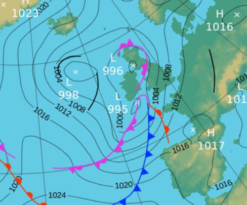
 1200 Hrs 5th - the low pressure system that saw the 5th become (to date) the year's wettest day
Wettest yet recorded - two very wet days and despite being warmer than average with a decent warm and dry period 13th-21st, overall a disappointing month.
If you had put your wellies away for the summer you were probably dusting them off at the start of the month and certainly would have been doing so at the month's end - yes, June was wet and either side of a fairly decent period mid month, rain was a frequent companion.
Features of the month were two very wet days, 5th and especially the 28th which became the sixth wettest day in my records with 55.4 mm; prior to June no day had recorded an inch of rain during 2017, but now the total is two.
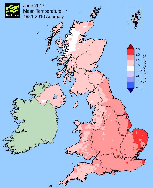
Then the mildness of the nights, many of which were into double figures and hence the mean minimum temperature for the month was significantly above average. Indeed it is solely down to the mildness of the nights that the month ended warmer than average.
Additionally and finally, the month ended somewhat chilly - were you one of those who turned the heating back on?
The 5th with 37.8 mm was a grim day and then the 28th saw steady rain from mid-afternoon lasting through to the following morning to notch up over 2 inches in a day! One other curiosity of June is that prior to this year the 3rd was (after 10 yrs of records) the year's driest day, having never had more than 0.2 mm - a fine and sunny day maintains that record. Also the 13/14/15th had never recorded 20°c in my 8 yrs of records, the only days in June that have failed to do so - now it is just the 13th and 15th.
MSLP of 1009.8 Mb was -5.6 Mb below the local average for June, pressure being at its lowest during 5-8th and at the month's end and whilst high pressure was with us for a week mid-month, it never rose that high, only attaining 1024.6 MB.
Overall a mean minimum of 10.39°c and a mean maximum of 17.57°c saw the temperature 1.0°c above the 1981-2010 average and it was the coldest since 2015. The highest maximum temperature recorded was 26.2°c (21st), the lowest minimum 3.7°c (3rd).
Rainfall of 160.1 mm (Crosby Ravensworth School 162.9 mm - Castlehowe Scar 169.5 mm - Reagill ??? mm) made it the wettest June yet recorded (of 11) and was 213.5% of average for 2007-16, it was also the wettest of any month since January 2016.
Locally, rainfall percentages were at least 150% of normal, more typically 175% and at a number of sites went well above 200% - which without any thundery activity are quite marked. Kirkby Thore at a whopping 276.3% of average totally belied its reputation for being the driest location in the county.
At the Met' Office site at Newton Rigg, 124.2 mm (212%) made it the wettest since 2012 and in a series back to 1900 there has been 111 drier and only six wetter. In a series back to 1952 a mean temperature of 13.65°c is the coldest since 2015 with 46 having been colder, 18 warmer and 1 having the same mean temperature.
Figures from the Environment Agency�s rainfall sites were, (figure in brackets being the monthly average for 1961-90) �Data kindly provided by the Hydrometry and Telemetry team of the Environment Agency (Penrith)�:
Kirkby Thore 116.6 (42.2 mm)
Haresceugh Castle (Kirkoswald) 121.89 mm (69.3 mm)
Brothers Water 226.32 mm (131 mm) and
270.6 mm at Seathwaite Farm (Borrowdale - 177 mm [average for 1981-2010])
1st - 12th Low Pressure systems (LP) were a regular visitor to the UK at the start and indeed, well into the month and rainfall totals quickly began to tot up and it was also on the cool side as well.
Low pressure in the mid Atlantic west of Eire became virtual static during the 1st-3rd with fronts spiralling off from it, bringing some spells of rain. The 1st managed to see sun before clouding over from tea-time with the first rain arriving (4.5 mm - credited back to the 1st) arriving in the early hours of the 2nd.
After a dull and drizzly start, the 2nd brightened up quite nicely in the afternoon and the 3rd and 4th saw us manage to stay dry (apart from a shower at 0900 hrs on the 4th) and see some sunshine although the 4th was quite breezy.
However, during the 4th an unseasonably low pressure system was building to our SW and which would move NE to be positioned just off the north coast of Eire/SW Scotland on the 5th - this resulted in the 5th becoming the wettest day of the year to date.
The rain started in the early hours of the 5th (giving 6.8 mm credited back to the 4th) and apart from a brief lull during the afternoon saw rain fall all day and continue into the 6th. The rain and murkiness saw the visibility reduced sufficiently to record a 'day of fog' and for a time the rain fell quite heavily in the early afternoon - the final total of 37.8 mm makes it my wettest June day (11 yrs of records), beating the 35.5 mm of the 11th in 2007 - but only for a short while as the 28th easily eclipsed the 5th.
1200 Hrs 5th - the low pressure system that saw the 5th become (to date) the year's wettest day
The LP exited out into the North Sea giving a couple of windy days 6-7th. The wind was brisk and from the NW and which apart from bringing some drizzle, was quite cold and consequently the 6th only attained 11.9°c (53.4°f), the month's lowest maximum.
A slight ridge of high pressure (HP) saw a transitional day on the 7th that was still windy, but with some sunny spells, before the next area of LP arrived from off the Atlantic which resulted in a poor day on the 8th with 7.0 mm of rain.
The theme was one of being unsettled with a steady stream of LP systems separated by a transitional day and so it continued. The 9th saw early rain clear, before yet another area of LP arrived late in the evening and this system would sit in the Atlantic to the west of Eire and be the dominant feature for the next couple of days.
Rain overnight into the 10th gave 5.7 mm (credited back to the 9th) and the 10-12th all saw some rain, although mainly in the form of showers with the 11th also being a windy day - temperatures during the period being down on the average.
13th - 21st HP had been dominant over Europe upto this point and apart from the occasional incursion of a weather front, would now steadily take control of our weather, subsequently we enjoyed a more settled and increasingly warm and sunny period of weather.
The improvement was gradual at first, more a case of occasional weak sunshine and steadily warming, although that weak sunshine was enough to see the 14th attain 21.0°c.
However, one of those 'occasional incursions' of a frontal system came during the 15th which gave some rain at both ends of the day - but then the 'Azores High' re-established itself.
The 16th would be classed as a transitional day, but from the 17th with the HP firmly in control, the days became dry, sunny and hot. The breakdown on the 21st saw some thunder and sultry conditions.
Sunny and a pleasantly warm 21.6°c on the 17th was followed by 24.0°c on the 18th and then the 19th was hot. It was already 21.5°c at 1000 hrs and the day would peak at 25.8°c before something slightly cooler and cloudier on the 20th as a cold front moved south.
Thunder was heard in the early hours of the 21st and after one sharp shower at 0600 hrs, the thunder rumbled in again at 0830 hrs and gave a short but quite intense spell of rain. LP had developed to the SW and pushed a series of fronts north into the pool of hot air and thus the thunder and sultry conditions. The day would peak at a year's high of 26.2°c (79.2°f) and come 2300 hrs it was still above 20°c and after a succession of uncomfortably mild nights, this was the worst.
That area of LP would move north and merge with LP near Iceland, its associated fronts trailing over the UK and finally clearing east late on the 22nd allowing a brief ridge of HP to build behind.
23rd - 30th The warm and sunny weather had come to an end and now through to the end of the month the theme was unsettled and wet - the only good thing being that the gardens certainly needed a drop of rain!
That LP near Iceland would dominate for the next few days as it slowly trundled east, although any rain was mainly confined to the early hours of the 23rd which then saw occasional bouts of drizzle. The main difference was the drop in temperature to just below 17°c.
Somehow on the 25th we managed to stay dry despite the proximity of frontal systems, but with HP in the Atlantic starting to build, winds were now from the NW and this gave a chill to a steady breeze. The HP would give a calm if unspectacular day on the 26th, but this was only ahead of a new LP system that would bring the cool and very wet conditions.
The LP arrived from the SW overnight into the 27th and would remain over the UK to the month's end with a second LP building off the east coast; the associated frontal systems would give a prolonged period of rain.
The rain in the early hours of the 27th gave 9.7 mm (credited back to the 26th) and continued through the day to give another 7.9 mm. The 28th started with light rain, but come 1500 hrs it turned heavier as a new belt of rain arrived from the SE and the rain just continued, at times heavily through to mid-day on the 29th. This gave the final total for the 28th of 55.4 mm (2.18 inch), the new wettest day of the year.
Whilst the temperature remained constant all day, unfortunately it was constantly cold at just 12.0°c as was the 29th and was more akin to autumn than summer.
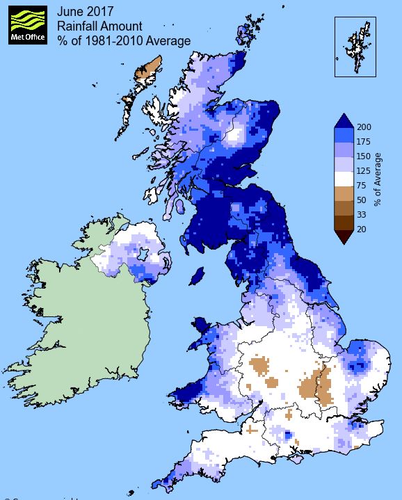
Rainfall totalled 160.1 mm for the month, with rain recorded on 19 days of which 16 were 'Wet days' (1.0mm +).
The Mean Temperature for the month was 13.98°c -- The Mean Max' was 17.57°c -- The Mean Min' 10.39°c.
We had 0 Air Frosts in the month (year 32) -- Grass frosts totalled 0 (year 67).
The 1 foot soil temp ranged from a low of 13.8°c on the 30th to a high of 17.7°c on the 22nd -- with a monthly mean of 15.2°c
The 1 meter soil temp ranged from a low of 12.0°c on the 11-12th to a high of 13.7°c on the 25-26th -- with a monthly mean of 12.7°c
COMPARISONS:-
* June 2017 rainfall was 213.5% of the average for 2007 - 2016
* June 2017 was 0.9°c warmer than the average for 2009 - 2016 and 1.0°c warmer than the local long term average 1981-2010
* This makes the Jan' to June period of 2017 some 1.12°c warmer than the average for 2009-16 and with 88.3% of average rainfall for 2008-16
JANUARY 2010
FEBRUARY 2010
MARCH 2010
APRIL 2010
MAY 2010
JUNE 2010
JULY 2010
AUGUST 2010
SEPTEMBER 2010
OCTOBER 2010
NOVEMBER 2010
DECEMBER 2010
JANUARY 2011
FEBRUARY 2011
MARCH 2011
APRIL 2011
MAY 2011
JUNE 2011
JULY 2011
AUGUST 2011
SEPTEMBER 2011
OCTOBER 2011
NOVEMBER 2011
DECEMBER 2011
JANUARY 2012
FEBRUARY 2012
MARCH 2012
APRIL 2012
MAY 2012
JUNE 2012
JULY 2012
AUGUST 2012
SEPTEMBER 2012
OCTOBER 2012
NOVEMBER 2012
DECEMBER 2012
SUMMER 2012
REVIEW OF 2012
JANUARY 2013
FEBRUARY 2013
MARCH 2013
APRIL 2013
MAY 2013
JUNE 2013
JULY 2013
AUGUST 2013
SEPTEMBER 2013
OCTOBER 2013
NOVEMBER 2013
DECEMBER 2013
REVIEW OF 2013
JANUARY 2014
FEBRUARY 2014
MARCH 2014
APRIL 2014
MAY 2014
JUNE 2014
JULY 2014
AUGUST 2014
SEPTEMBER 2014
OCTOBER 2014
NOVEMBER 2014
DECEMBER 2014
WINTER 2014
REVIEW OF 2014
JANUARY 2015
FEBRUARY 2015
MARCH 2015
APRIL 2015
MAY 2015
JUNE 2015
JULY 2015
AUGUST 2015
SEPTEMBER 2015
OCTOBER 2015
NOVEMBER 2015
DECEMBER 2015
REVIEW OF 2015
JANUARY 2016
FEBRUARY 2016
MARCH 2016
APRIL 2016
MAY 2016
JUNE 2016
JULY 2016
AUGUST 2016
SEPTEMBER 2016
OCTOBER 2016
NOVEMBER 2016
DECEMBER 2016
REVIEW OF 2016
JANUARY 2017
FEBRUARY 2017
MARCH 2017
APRIL 2017
MAY 2017
OTHER ARTICLES
The Oldest Inhabitant
An Inch Of Scotch Mist
© Darren Rogers 2010-17
Want to comment on this site? email